Chapter 1 - Introduction
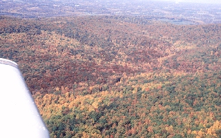
The early morning light came over the right wing, just illuminating the changing fall leaves in the
woods below. No fog. I had half expected that the "cat's paw" fog I had seen the night before
drifting like ghosts between the trees and wandering across the road would have grown into a
solid fog. Logic had convinced me that the morning air would be different because of the weak
cold front which was due through in the night. Timing was critical because if the front came
through in the wee hours of the morning, radiative cooling could allow the fog to remain in a
deep cold inversion. I had booked the club plane for four hours because of the possible late start.
Fortunately, I didn't have anywhere to go. I just wanted to stretch the wings.
Half an hour after dawn, I completed my preflight inspection. The tanks were topped off. I remembered a story of a friend who had not filled his tanks before he took off to do some photography at dawn. As dawn broke, the fog started to form. He got spectacular photos but the airport was socked in for an hour and a half until the morning breeze mixed the air up. He landed on vapor both outside and inside the wings.
Morning fog is most likely to get thickest an hour after sunrise, when the incoming sunlight just balances the outgoing infrared radiation. Sunlight, the heat which drives the atmospheric engine, works only half a day while the sun is up. The outgoing infarared heat is lost to space all the time. These two heat flows balance an hour or so after sunrise and before sunset. There was a possibility that some fog could still form. But, dew points were down from yesterday, there was a wind direction shift and the speed had picked up from yesterday's dawn, as well as a strong indication of frontal passage in the night making it highly unlikely. With this in mind, I taxied out, did my run-up, and launched into a beautiful fall day.
For me, the aim of flying was never to get from point A to point B. I'll leave that to the ladies and gentlemen who fly the air carriers. For me, a flight from Montgomery Airpark, north to Frederick, Maryland, the home of AOPA, and then over the mountains can contain a lot of interesting weather. One of my favorite spots for air work is around Sugarloaf Mountain in Maryland. Sugarloaf is a good landmark for anyone coming to the Nation's Capitol from the North or Northwest. If you are below 4,500 feet, it sticks out like a loaf of bread on the platter of the rolling Piedmont right at the northern edge of the Washington Class B airspace.
Sugarloaf also "makes its own weather," most frequently providing turbulence downwind. Some
days the turbulence extends miles downwind, other days only affects the air near the mountain.
On still other days, the air flows smoothly around the mountain and is not really turbulent at all. I
learned early to avoid Sugarloaf on hazy days. If visibility was under five miles at home, it was
almost certainly less than that near Sugarloaf. It only took one encounter for me to see the
practical aspects of the theory of up-slope flow that I had studied as a graduate student. So, I
found that I wanted at least a solid five miles visibility to use the mountain. I want to be able to
see the water tower we use as a visibility marker clearly before I go to Sugarloaf to do air work. I
suppose some would say that I worry too much, that I could just go elsewhere. True, but the
Class B airspace around the D.C. area is somewhat confining and a misstep might mean the
meeting of aluminum.

Perhaps it's the worry that prompted me to approach flying the way I did. Most people apparently decide to do it, go over to the FBO and start lessons. I did it backwards. While studying the physics of clouds in graduate school, it became apparent that there was considerable lack of knowledge about the sub-cloud layer, the realm of general weekend aviation. I decided then that as soon as finances would permit, I would learn to fly. During the process I gained a wife and three children, so it was some time until finances permitted. Clubs work most of the time but sometimes have their problems.
It took years for me to finally get my license. I continued my instruction slowly, and because of the slowness, was able to sample a number of different instructors, many of them excellent. The major instruction on weather seems to be on how to get a briefing, the minimums for controlled and uncontrolled airspace, and how to fly, take off, and land in a crosswind. These are important and must be stressed. But somehow I felt that something was missing.
Perhaps when I told the instructors where I worked, it intimidated them. I don't know. I pointed out that I was most interested in learning about the weather and needed any practical advice, but still didn't get much. Most of the time, the go/no-go decisions were made on what we wanted to accomplish. I should have realized that, except for the FAA controlled/uncontrolled airspace rules and the manual's proud proclamation that some test pilot with a new plane in tip-top shape had landed on some almost perfect runway in a crosswind of umpty-ump knots, there aren't any. The idea seems to be - stay out of what you are uncomfortable with. Finally, I decided that if the instructors were willing to fly, I would go along. This didn't help much making the decisions before making a solo flight.
I read extensively and that helped. Buck's book Weather Flying is good and so are some of the others. Probably the best on straight elementary meteorology is the old standard, Aviation Weather (AC 00-6A) published by our government. Yet, I had the feeling that somehow most pilots learned about flying in weather by trial and error. And that idea worries me.
Then one winter's day I was at the airpark just watching a quiet field. The ceiling was at 4,000 feet, with forecast and reported icing at 4,500. Winds were out of the Northwest at 15 knots. I had decided the day was for popcorn and a good book when I heard my instructor giving instructions to another student for a long cross-ountry solo flight to Williamsport, Pennsylvania. Almost as an afterthought, he asked me about the weather. I asked him if the student had gotten a briefing. He said yes. It was technically VFR all the way - what did I think?
I told him that it looked to me that the student would have a highly interesting flight, and that I wouldn't go. I realized that if the student got into trouble over some of the 3,500 foot high rocks enroute, and it was always possible to have some interesting turbulence with the winds perpendicular to the ridges, he could always scud run over the Susquehanna River. There was only one big set of high tension lines across the river along the way that I knew about. I still don't know if the student went, but there were no damage reports when I checked the next day so I assume he didn't.
I do know I found a new instructor.
I finally adopted the attitude that if the instructor wasn't aboard and I didn't like it, I went home. One writer said that after the first hundred feet in the car headed away from the airport, the stress of a go/no-go decision evaporates and a feeling of relief sets in. That's true.
Yet, to get utility out of an expensive investment, one needs to be able to fly in less than optimal weather. There are very few days where the ceiling and visibility are unlimited over your entire route. Most long trips have at least one bout of weather. Some you can go around the sides; some you can land and wait for it to go over you. If you're not willing to make adjustments for bad weather, you should get an instrument flight rules (IFR) rating and have the attendant commitment to keep it current. In either case you should have a good working knowledge of meteorology.
It's getting harder and harder to talk to a human being. And, because we don't practice as often, it is harder to ask good questions to get the most out of the briefing. Part of the problem is that word "good." Most people think it encompasses everything, and then some, in an easily digestible form. It doesn't. It means what is right for your purpose. That's why the Flight Service Specialist needs to determine your plans and capability before launching into the weather information.
With the wealth of new on-line automated computer services being installed at airports, budgets are tougher and resources could be cut. For some reason, the budget cutters (local, state, and Federal) feel they need consolidate the systems, automate them, and then move the people and positions somewhere else to attack new problems. With automated systems, you often get more than you need of one kind of information and less than you need of other types. The idea is to separate out the kernels that you need from the chaff which somebody else needs but you don't. In this automated age, knowledge is the only way to make a reasonable decision.
A go/no-go decision begins well before the weather briefing. Anyone who listens to the radio or watches TV hears weather forecasts frequently. Pay attention to the forecasts a number of days before a long flight and you will get a sense of how the forecasters are doing. If the forecasts are right on, the forecast system is working well; if the forecasts are off, dig deeper during the briefing to find out the problems if possible. This doesn't mean that the forecast given during the briefing will be good, but at least you will be able to adjust the forecasts better and be more aware of the likelihood of things going to pot.
There are some periods when the forecasts seem to be perfect and others where they can't seem to get it right the next hour. There are reasons for this inherent in the physics of the atmosphere, our means for measuring these flows, and our methods for interpreting the flows. In fact, the study of these problems has given rise to a whole new branch of mathematics and physics called Chaos Theory.
Understanding the whys and wherefores of the atmosphere may help make flying safer, and perhaps reduce your need for extraordinary skill, by helping you avoid extraordinary circumstances. In fact, that's the reason for this book: to describe those parts of the field of meteorology which are most relevant to flying so you can get a better weather briefing next time - even if you are doing it electronically.
It sounds like a big job for a pilot to know all the scales of weather, those you can see as well as those you can't. I have to confess that I let my favorite computer model do the organizing at the global scale, perhaps because I have confidence that they can do a better job than I can. A serious forecaster will spend considerably more time and effort on the large scale maps. They can see patterns in the data and flows which the computer either smooths out or can't handle. Only when things are dicey do I go back and start comparing the different computer simulations. I usually follow the highs and lows and locations of high risk for convection on the Northern Hemisphere scale analyses and predictions made in the middle of the atmosphere by weight and the surface. Much of the information is readily available on TV or the Internet. After I have some feeling as to how fast the systems are moving and their tracks, I start looking at the smaller scales which will have a more direct influence on my flight. After all, the flight is the main thing.
After I am done looking at the flows on the scale of the contiguous U.S., I concentrate on the smallest area along my line of flight for which there are sufficient data that I am comfortable will show up discrepancies. In the Northeast US, that usually means about nine or ten states, Ohio to Massachusetts and New York through Maryland/Virginia area. Here again, I look for the air flow over the region, as it will be pretty typical of what I should find as long as I am at altitude. Getting closer to the ground, as in the critical eight minutes - the first three after takeoff and the last five before the rubber meets the tarmac, means looking at the local influences. These are often quite different than those seen aloft. Think back to your last landing in hilly country on a windy day.
So the surface data I look at are, for the most part, taken next to the runways of the same airports. If it's windy, the data taken at the hilly country airport will reflect the local effects. And these, in turn will be influenced by the amount of sunshine and the large scale wind flow. Perhaps the best way to see this is by describing a flight from Maryland to New York the wife and I took some time ago.
Onward to Chapter 2
Back to Table of Contents ©